
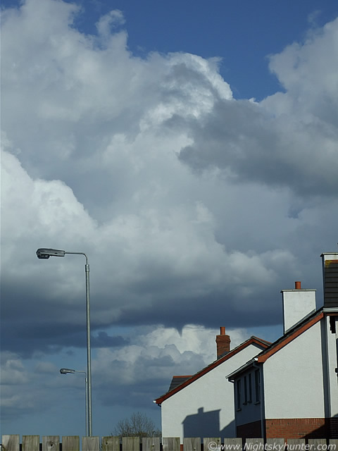
The afternoon of May 10th 2009 was warm and sunny over Maghera, N. Ireland. However, there was some convection evident. The blue sky contained regular slow moving clusters of Cumulus Med and Cumulus Congestus/Updraught Towers. With very little instability and no convective forecast issued I was very surprised to see such good quality clouds around. I knew something was going to happen when I observed a very impressive Updraught Tower rotating, not just the base, but the entire tower itself was bent over and moving in a corkscrew fashion which was stunning to watch. This movement, and the visual structure to the updraught base, on this, and on other towers, indicated a high chance of a funnel. A quick check on the convective maps showed a large area of vorticity over N. Ireland which confirmed my visual impression.
I spent one hour in the country watching more. A line of Updraughts merged together and the entire cluster rotated around, similar a large wheel at a fairground, directly above my head. I watched this spinning platform of cloud for that entire period while a weak shower formed. Nothing dropped from it so I went home. I had my dinner and made a mug of tea and did a quick check of the sky from my back door. In the E was a line of Cumulus with one nice Updraught Tower. It looked promising, and just as I thought that, a funnel cloud formed directly in front of me from that base, below the tower. It was rotating fast, formed an inverted cone shape which was slightly elongated in the vertical orientation. It lasted for approx 5 min's while it changed shape from a cone to a stump with a slight curve, relaxed a little, then tightened up the rotation again before forming another cone. It then fizzled out. I got a few snaps from my back door step. It did not extend down very far at all and was hardly spectacular, however when you are not really expecting much it seems all the more wonderful. It was quite exciting to watch, and if I'm to be honest, my hands were shaking while holding the camera. Most of the images I took are wide angle which makes the funnel look smaller than it was, however I wanted to show the funnel and its parent cloud in the same frame. The funnel really made my day, this is my first sighting of the 2009 season. I hope to get bigger and better over the next few months. Amazingly, this was the exact same place where I seen a funnel cloud last August!.
 |
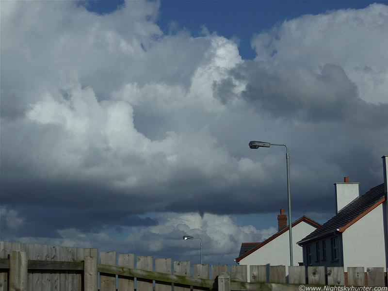
I managed to get half a dozen images of the funnel so I was lucky to have had my camera so close to hand. Had it been in a different room in the house, or had I spent longer at my dinner, I would have missed it completely. The funnel was clearly at its most photogenic stage when it first formed, however I only got this image of that period because I wasted five other images trying to find the correct shutter speed and focus for the scene. This image is my favourite of the day. You can see that this is a classic example of a cold air funnel cloud which has formed directly under the primary Updraught Tower of this Cumulus Congestus. As you can see, there is no evidence of wind shear on that tower. The dark funnel looks nice and contrasty against the white colour of the distant Cumulus cloud. This may have been larger than what it seems, that cloud base is quite elevated and the distance may be greater than what I thought at the time so this could be big enough. The convection is moving very slowly from L to R. Facing E.
 |
I took several zoomed in images but I decided that the wide images look much better for this account. It's quite amazing to see a funnel cloud from your own back yard, I'm actually standing on my steps, almost within the door frame itself. This was been 16.10 and 16.15 BST. It's amazing how unobservant some people are though, there was a gang of young men all standing outside to my L who were staring at me as I snapped away with the camera in hand. However, not a single one of them even glanced a the sky, even out of curiosity, to see what I was taking images of. So, they never seen the funnel, in fact, I don't know of anyone else who did.
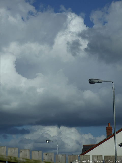 |
Last image. The rotation of the funnel is dragging some scud around as the vortex tightens up for a last spin-up before relaxing and fizzling out. Even though I have seen spectacular funnel clouds in years past, this little one really got me excited. It felt like a special little present from mother nature, perhaps a reward for all the recent effort I have put into convective photography this year. When it vanished I had to tell someone so I phoned John McConnell in Maghaberry and informed him in a controlled but excited manner what I had seen. The airmass was so slow on this day that the line of convection which produced the funnel was still visible in the E with good structure and new Towers slowly bubbling up. The base still had 'the look' so I spent some time watching incase another dropped while the Sun burned me. What a day!. This brings the number of funnel clouds I have seen to 15 (?) since July 17th 2007. In the months ahead I hope to get much larger and more spectacular versions of this guy. Thanks for reading.
Martin McKenna